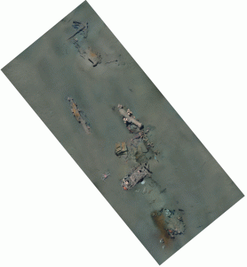
Pre-Disturbance Photomosaic of the Mardi Gras Shipwreck in 2007.
The Mardi Gras wreck was first recorded during a 2001 remote sensing survey for the Okeanos Gas Gathering Company’s proposed pipeline route in the Mississippi Canyon leasing area. The side scan sonar image appeared as a nebulous feature on the seafloor not clearly indicative of a shipwreck. An ROV inspection of the proposed pipeline route in 2002 for the operator determined that the sonar target was indeed the remains of a wooden-hulled vessel but the operator failed to notify MMS (now BOEM and BSEE) of the discovery. MMS later learned of the site in 2004 and was able to briefly visit the wreck for visual documentation and collection of two diagnostic artifacts to assist with dating the site. In 2005, C&C Technologies conducted an AUV survey to collect multibeam bathymetric data at the site. A 2006 ROV investigation of the site overseen by MMS archaeologists performed additional video documentation.